World Map in 650 A.D.
Explore My Maps
World Travel Destinations
PaintWorld🎨
Place Names in Sakhalin
Equal Earth Physical - Chinese
https://zhaoxusui.github.io/2021/02/10/World_GDP_Density/Home
Homehttps://zhaoxusui.github.io/2019/06/15/Hangzhou_Nanjing/https://zhaoxusui.github.io/Great_Wall_Draft_Updated.jpghttps://zhaoxusui.github.io/2015/04/01/illustrated_map_of_the_world/World_Map.jpghttps://zhaoxusui.github.io/2021/12/12/Travel_Map/Travel_Map_Smaller.jpgParticipated in NACIS Student Competition
Sahara is traditionally believed as a barren desert around the world. By making this map, I would like to present you different but more vibrant landscapes throughout the Sahara, where you will have a chance to look at hidden gems such as castles, oasises, national parks, caravan towns, and other amazing places within the largest desert of the world.
SE Asiahttps://drive.google.com/file/d/1pCeBEqPCcgEFAwTZPCOkAdaV0i_MJCNA/viewGlobeGlobal Highspeed Transit Network
Jinan River Flood Risk Assessment
https://zhaoxusui.github.io/2019/08/15/China_GDP/https://zhaoxusui.github.io/2021/05/24/Lost_Creek_Hiking_Trail/Layout1.jpghttps://zhaoxusui.github.io/Dark_SC.jpgParticipated in BCS Map Competition
Map of Jinan - My Hometown
https://zhaoxusui.github.io/2019/12/20/Great_Bay_Area_RTN/Great_Bay_Area_RTN.pnghttps://zhaoxusui.github.io/Earth_Transit.pdfZhaoxu Sui
https://zhaoxusui.github.io/Cusco_Low_Res.jpgPennsylvania Reference Map
World Physical and Political
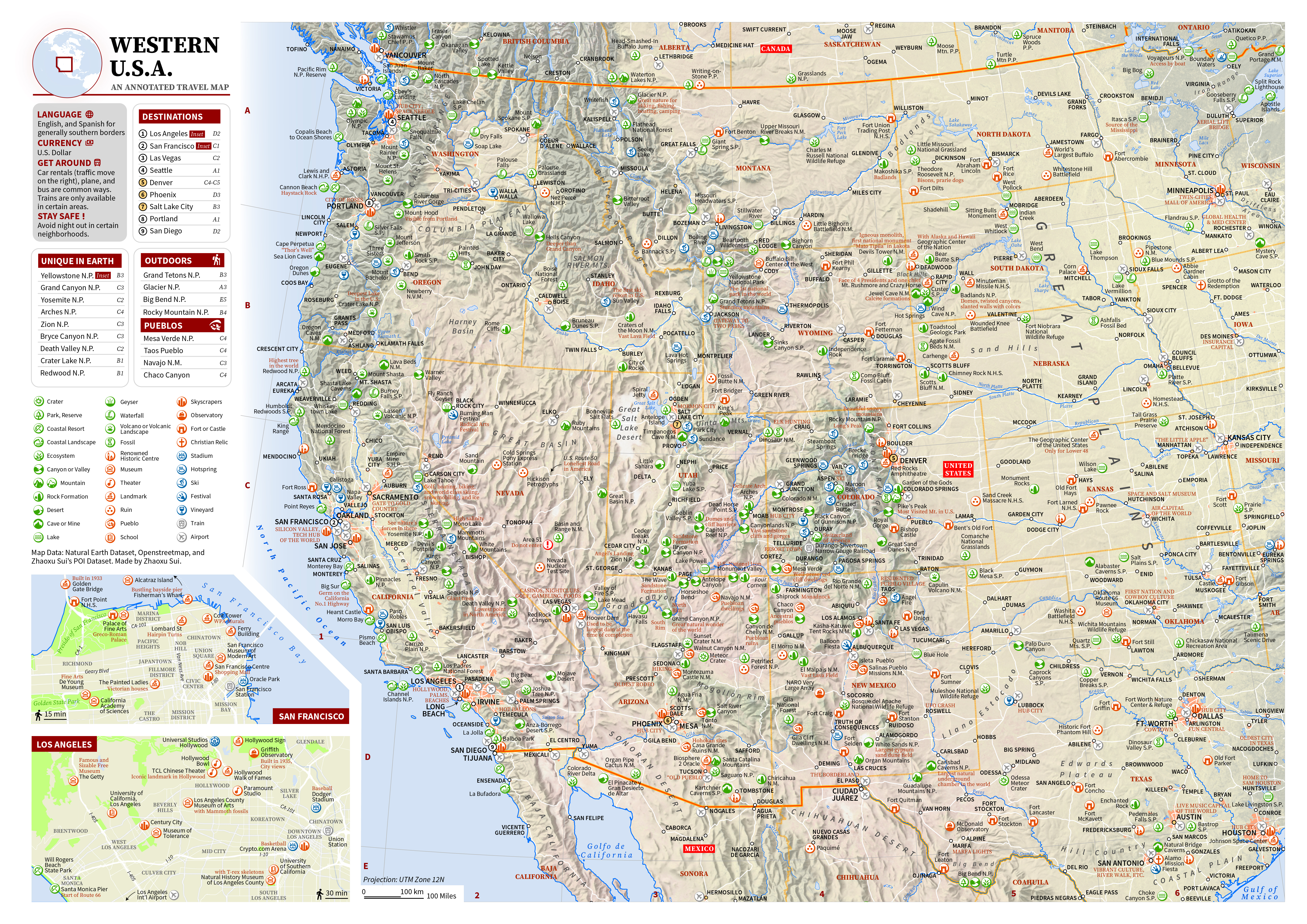
I used creative icons and annotations in these two maps to emphasize various travel attractions and activities. Both clear visual hierarchies and helpful anciliary information helped me placing dense features into harmonies. The Annotated Travel Map of Western United States is presented in the NACIS 2024 Annual Conference Map Gallery.
https://zhaoxusui.github.io/Light_SC.jpgMy Journeys in the North America
HomeDo you want to explore famous paintings around the world? Try out this web map! Simply open the list and search for paintings, artists, or museums that you are interested in, and enjoy the journey!
https://zhaoxusui.github.io/2020/10/14/Metro_Transit/Braile Map of EMS College, Penn State
PSU OGE Alumni Map
Travel Map of the World
Honorable Mentioned in Univ. of Oregon Bill Loy Award
State College Area - Dark Version
GDP Map of China
Contact
Contact Pagehttps://storymaps.arcgis.com/stories/3f5d22a17fe5438c947ca539c2b8966eBlack & White Maps of Selected Areas
Dynastic Mansory - Great Wall of China
Cusco and Surroundings
A Travel Guide to Southeast Asia
A 3D Relief Globe
Explore this Work!
Explore this Work!Map of Sahara
https://zhaoxusui.github.io/2023/03/01/Equal_Earth_ZH/Equal_Earth_ZH.jpgMetro Map of Beijing, Shanghai, &Seoul
In 2017, I made a 3D relief globe by a series of procedures. I gave a talk in the NACIS 2024 to illustrate how I made this globe. You can access my work here.
https://zhaoxusui.github.io/650ADEnglish.pngHonorable Mentioned in CaGIS Map Competition
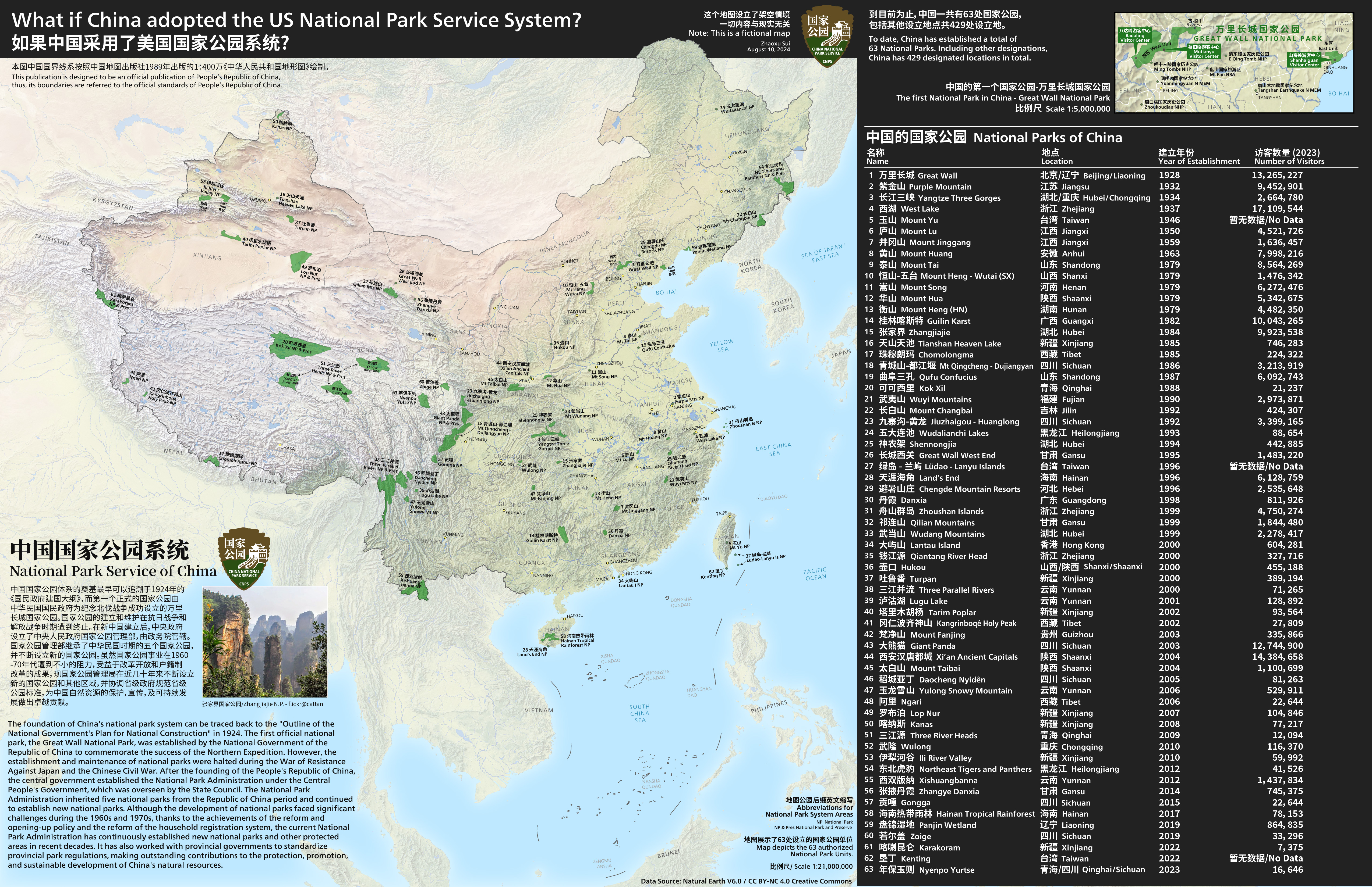
https://zhaoxusui.github.io/2023/09/02/World_Physical_World_Political/What if China adopted NPS System?
Explore this Work!
Transit Map of Greater Bay Area
A Set of Maps - Cartographic Work thoughout Classes
SE AsiaBuildings glow in the dark, right? In this map, I used Adobe Illustrator to mimic buildings and roads with outer glow effects. Along with a Day Version (->) of the State College Area, I contributed these two pieces to the GeoGraphics Lab at Penn State.
About
https://zhaoxusui.github.io/Western_USA.jpgAll maps are in CC BY-NC 4.0 Creative Commons.
https://zhaoxusui.github.io/London.jpgParticipated in ICC Exhibition
Earth Transit
How to be a cartographer? Before entering universities, I have relied on my hands for a long time, hand-drawing various areas of my interests, but I started to learn about my digital mapping in Fall 2020, which completely opened up a new horizon of cartography works that I could make. Here I would like to invite you to see some of the first ones that I made by using ArcGIS Pro.
Hand-drawn Maps of Selected Areas in the World
https://zhaoxusui.github.io/2018/05/27/illustrated-maps-of-various-regions/Bilingual Map Series of the World
Awarded in Univ. of Minnesota U-Spatial Competition
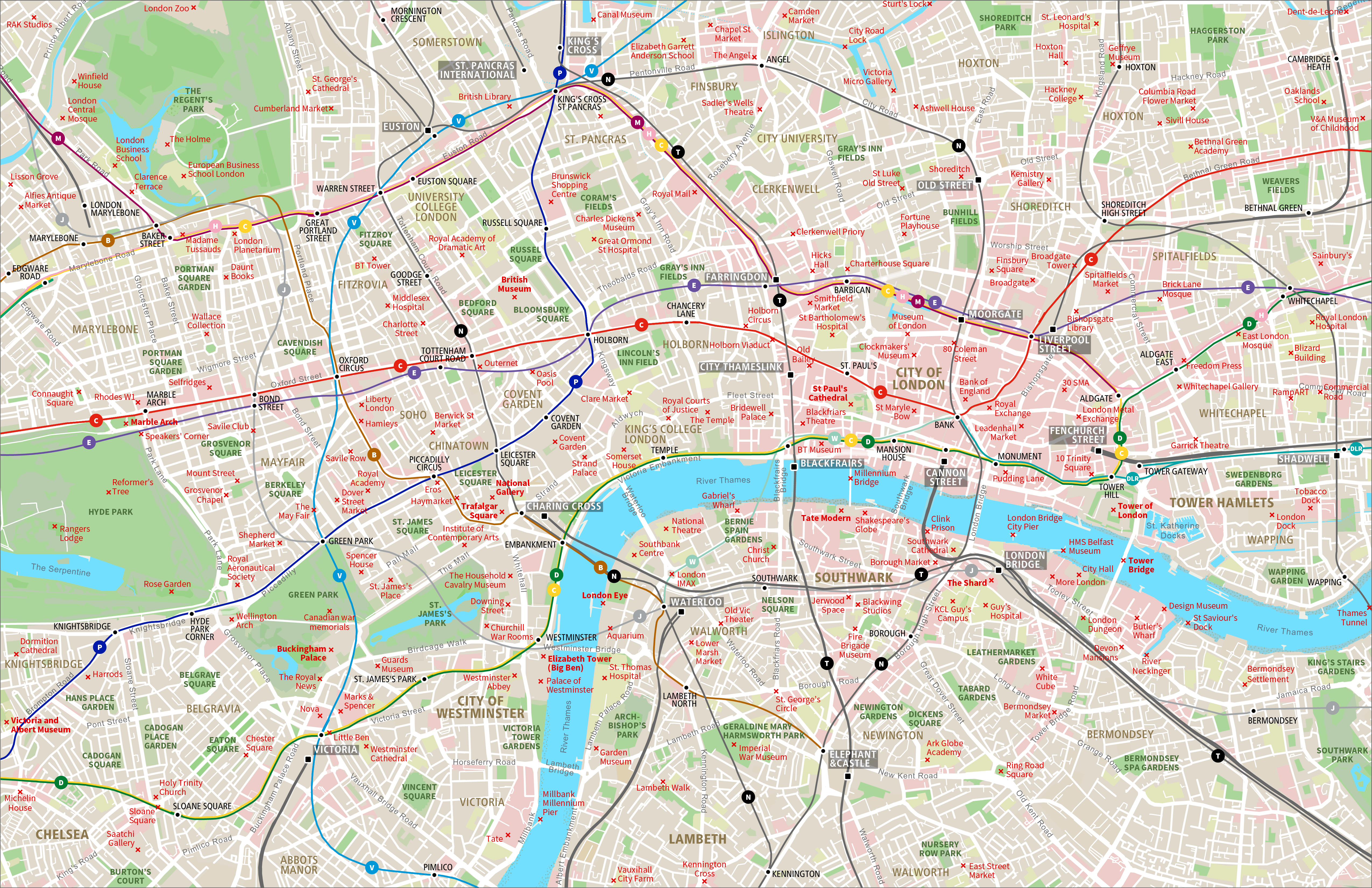
https://zhaoxusui.github.io/CN_NP.jpghttps://zhaoxusui.github.io/2020/10/09/Intro_to_Cartography/https://zhaoxusui.github.io/2017/08/29/black_white_maps/A Map of London
https://zhaoxusui.github.io/Jinan_Springs.jpgComprehensive Map of the World
https://zhaoxusui.github.io/Global_Highspeed_Transit_Network.jpgIn 2021, I completed my B.S. Degree with a capstone project simulating areas with greatest flooding risk in my hometown, Jinan. The assessment is presented in the Esri Story Map.
Explore this Work!
https://zhaoxusui.github.io/2023/07/30/Jinan/Jinan.jpgMap of my High School Campus
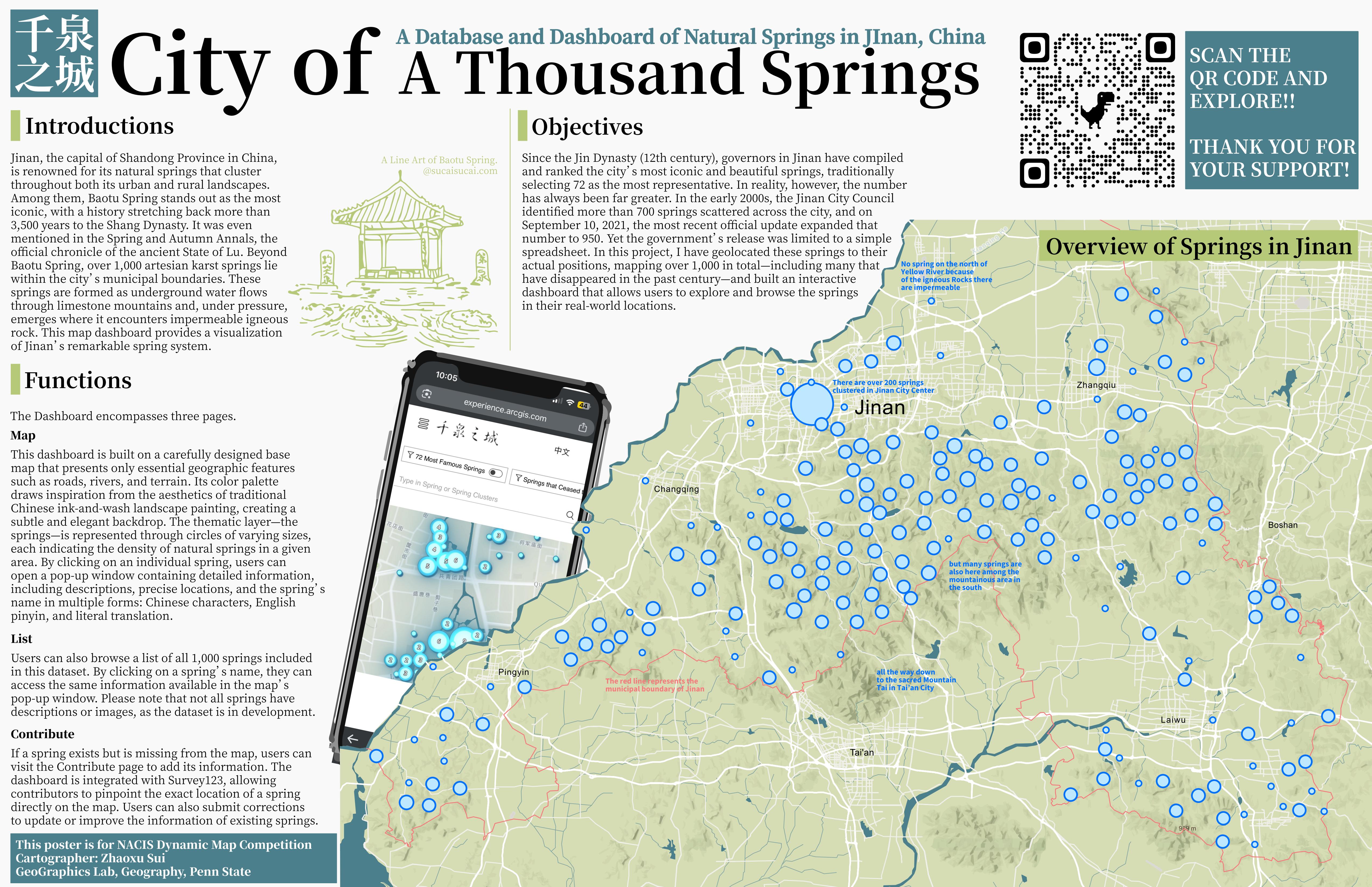
Springs of Jinan Poster
Hand Drawn World Map in 2018
https://zhaoxusui.github.io/Himalaya_Compilation.jpghttps://zhaoxusui.github.io/Assignments/Final_Project/Sakhalin_Places.html#https://zhaoxusui.github.io/US_Road_Map_English1.jpgExplore this work!
Globehttps://zhaoxusui.github.io/Sahara.jpghttps://experience.arcgis.com/experience/c079719457414fd1a3cbc09b879300d5/Maps of Nanjing, Hangzhou, & Boston
Thematic Map Series about World GDP
Annotated Travel Maps of Mexico & Western United States
Himalayan Mountainscapes
Map of Lost Creek Hiking Trail, MN
In 2021, I compiled my maps together and came up with a section focus on traveling in Southeast Asia. Please enjoy!